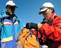
A 24-member team of researchers on a mission to re-measure the world’s highest peak reached the summit on Sunday, erecting a survey beacon and a GPS (global positioning system) monitoring station for measurements over the next two days and in the future.
"Determination of Mount Qomolangma's height has an important bearing on our lives," said Zhang Yanping, chief director of the mission, "What attracts people's attention is not only the height of the peak, but also changes in its height and geological changes in the area, which will have a great impact on the global biosphere, atmosphere and lithosphere."
This is the second Chinese endeavor to measure the mountain, also known as Mount Everest, in the past three decades. The first, in 1975, found the height to be 8,848.13 meters above sea level.
This time, they also used a radar device to detect the thickness of snow and ice so that it may be excluded from the height measurement.
The GPS and radar device should provide a more precise result, though the traditional trigonometric leveling method used in the last expedition is still being used for comparison.
The team started its final climb at 3:30 AM from a camp 8,300 meters above sea level and reached the top at around 11:08 AM, braving strong gales and temperatures as low as minus 29.6 degrees Centigrade. They began their descent at 12:25 PM.
This stage of the mission was postponed several times from the original planned date of May 5 to May 22 due to bad weather conditions.
"Results will provide important data for the study of crust movements and for other geoscience studies," Chen Bangzhu, head of the State Bureau of Surveying and Mapping, said in a congratulatory message to the team.
The ongoing survey is part of China's fourth large-scale comprehensive scientific survey on Qomolangma, jointly organized by the Chinese Academy of Sciences (CAS), the State Bureau of Surveying and Mapping, and the government of Tibet Autonomous Region.
Scientists will also conduct research on the impact of global warming on glaciers and make observations of atmospheric physics and chemistry, biodiversity and environmental changes in the Himalayan region, said Zhang Jiangqi, a CAS researcher.
A monument will be erected at the mountain's base camp to mark the current measurement efforts. The final result is expected to be announced in August.
(Xinhua News Agency May 23, 3005)